 Spanish
 English
San Juan La Laguna
¡¡¡Land of the Tz'utujiles!!!
San Juan La Laguna
¡¡¡Land of the Tz'utujiles!!!
¡¡¡Land of the Tz'utujiles!!!
¡¡¡Land of the Tz'utujiles!!!
Formerly the name of the community was PATANA´X, whose meaning Pa = en, Tana´x = clay jar. Subsequently it was changed to CHO KUKU´ AB´AJ, or XEE´ KUKU´ AB´AJ * (meaning under / under the stone jar) It was named for its geographical location at that time. Located near the place with the same name, which was derived from the shape of a jar that had a stone that was in place, where a large amount of water was collected in winter time and that water was supplied by birds and all kinds of animals that were in the region. At the time of its foundation, recognized as a municipality, that an exact date is not specified, but it is confirmed that it was between the years 1,618 and 1,623, it was given the name of NEW PEOPLE OF SAN JUAN OR SAN JUAN ATITLÁN. At the end of time it was changed until calling, as it is now San Juan La Laguna.
The town of San Juan La Laguna was founded in colonial times, by residents of the town of Atitlán (today Santiago Atitlán), of the Tzutujil ethnicity, as indicated in an appraisal document ( list of taxes of Santiago Atitlán and its stays) of the year of 1,623, where it is given the name of New Town of San Juan. That document also notes that it was founded as a town, with its own council, between 1,618 and 1,623.
In 1643, Pedro Núñez de Barahona y Loayza, grandson of the conqueror Sancho Barahona, took possession of the encomienda that had originally belonged to Pedro de Alvarado. This commission included among its towns that of San Juan. In 1661, San Juan appears among the towns of the parcel assigned to Juan González Uzquieta, Cortezano of King Felipe IV. In 1667, it was for the benefit of the president of the council of Castile, Manuel Álvarez de Toledo and Portugal, Count of Oropesa.
By the year 1640, the inhabitants of San Juan Atitlán, as it was known at the time, held a dispute with those of the neighboring town of Santa Clara La Laguna, for the possession of several lands : Sanchicoc, Conopic, Sanchitijón, Cabalsuluc, Jacalnahulá, Comiac, Chatilpanac, and Chuyabaj. Within the process, the Clareños presented as proof of ownership, the document called: Title of the Indians of Santa Clara La Laguna ’, signed and dated in 1583, by the last Quiche kings, Don Juan Cortés and Don Juan de Rojas. The court agreed to divide the land in half between the two peoples and, apparently, this decision ended the conflict.
In the `` Geographical-Moral Description of the Diocese of Goathemala '', written by Archbishop Pedro Cortéz y larraz, on the occasion of his pastoral visit between 1768 and 1770, it is indicated that San Juan had 174 inhabitants and it was a town attached to the parish of San Pedro La Laguna.
An inventory of 1787, reports that the church had three altars and several images, indicating that it was a parish of some importance and artistic value. The temple was destroyed by the earthquake of April 2, 1902.
San Juan La Laguna, during the colonial period, together with Tecpán Atitlán or Sololá, integrated the Mayor's Office of Sololá when in 1872 the department of Quiché was created, San Juan appears among the 21 municipalities that belonged under the jurisdiction of the department of Sololá. Approximately 200 years ago, in the jurisdiction of the municipality populated centers were created, currently recognized as villages of the same. Which are: Palestine, Panyebar and Pasajquím.
In the municipal seat, the titular party in honor of San Juan, patron of the town, is celebrated from June 23 to 25. The main day is 24, when the Catholic church commemorates the nativity of Saint John the Baptist. In relation to the villages, each one has its own date and pattern. Palestine is celebrated on September 29 in honor of St. Michael the Archangel. Panyebar, celebrate the festivities in honor of San José Patriarca, on March 19 and in honor of Santiago Apostle on July 25. And the Pasajquím community celebrates the party in honor of the lord of Esquipúlas, on January 20th.
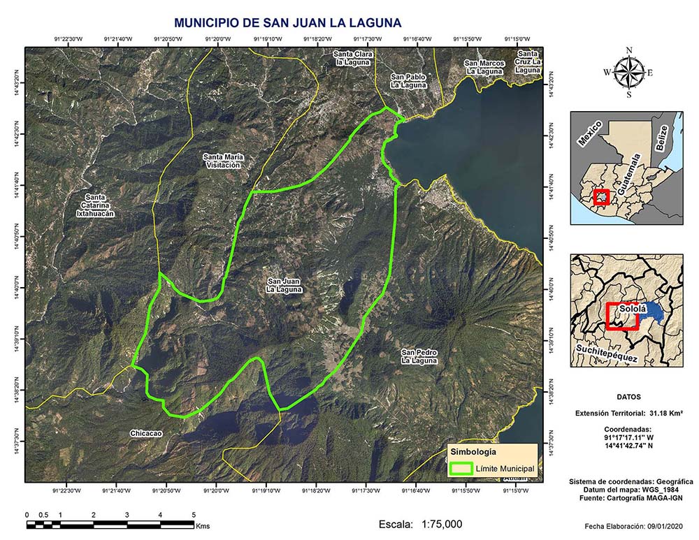
Read moreSurrounded by municipalities in the department of Sololá, except to the south, where it borders the municipality of Chicacao, Suchitepéquez.